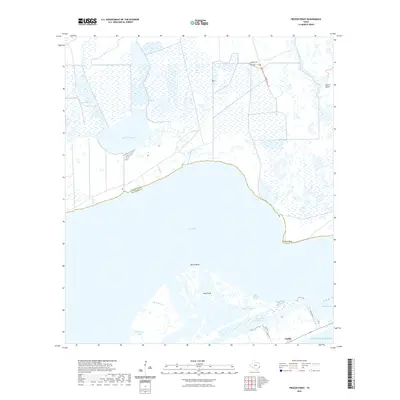
2022 Map of Frozen Point
USGS Topo · Published 2022About this map
The coastal marshlands and intricate bayous of the Texas Gulf Coast dominate this survey, where the terrestrial landscape dissolves into East Bay and the Gulf of Mexico. The boundary between Chambers Co and Galveston Co cuts through these wetlands, highlighting a region defined by water management and maritime transit. The Intracoastal Waterway serves as a critical artery for coastal commerce, bypassed by the small settlement of Caplen along the barrier coastline. In the interior, hydraulic features like Cane Bayou and Oyster Bayou drain into expansive shallow waters such as Robinson Lake and the Open Lakes. The presence of named paths like Levee Trl and Willows Trl suggests the ongoing importance of access for wetland maintenance and waterfowl management in areas like Gordy Marsh and Willow Marsh. Points of land such as Frozen Point and Marsh Point define the shifting shoreline of the bay.
Find a feature on this map
26 named features on this map. Tap any name to fly to it.
Don’t see what you’re looking for? This feature index may not catch every label — zoom into the map to look around manually.
Map Details
Editions of this 2022 Frozen Point Map
This is the sole edition of this map. No revisions or reprints were ever made.
Other maps of this area

1931 · Flake
USGS Topo · 1:24,000

1931 · High Island
USGS Topo · 1:24,000

1931 · Frozen Point
USGS Topo · 1:24,000

1933 · Frozen Point
USGS Topo · 1:31,680

1933 · Caplen
USGS Topo · 1:31,680

1933 · Whites Lake
USGS Topo · 1:31,680

1933 · Flake
USGS Topo · 1:31,680

1943 · High Island
USGS Topo · 1:31,680
1943 · Flake
USGS Topo · 1:25,000

1943 · Frozen Point
USGS Topo · 1:24,000