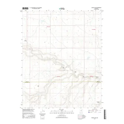
2017 Map of Frutosa Lake
USGS Topo · Published 2017About this map
The Mora River carves a deep path through the high plains of San Miguel County, creating a dramatic break in the landscape that defines this region's topography. As the river winds eastward, it passes through the steep walls of Garza Canyon, where the confluence with Pedroso Cr and other drainages has sculpted a series of side-canyons. The northern section of the map is characterized by elevated tablelands and scattered water bodies, including Morrison Lake and the namesake Frutosa Lake, while prominent landmarks like Mejan Mesa rise above the surrounding terrain.
Find a feature on this map
19 named features on this map. Tap any name to fly to it.
Don’t see what you’re looking for? This feature index may not catch every label — zoom into the map to look around manually.
Map Details
Editions of this 2017 Frutosa Lake Map
This is the sole edition of this map. No revisions or reprints were ever made.
Other maps of this area

1892 · Watrous
USGS Topo · 1:125,000

1894 · Watrous
USGS Topo · 1:125,000

1954 · Santa Fe
USGS Topo · 1:250,000

1958 · Santa Fe
USGS Topo · 1:250,000

1964 · Frutosa Lake
USGS Topo · 1:24,000

1964 · Mogote Hills
USGS Topo · 1:24,000

1964 · Alamosa Creek
USGS Topo · 1:24,000

1964 · Canon Ancho
USGS Topo · 1:24,000
1966 · Cherry Valley Lake
USGS Topo · 1:24,000
1966 · Optimo
USGS Topo · 1:24,000