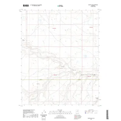
2020 Map of Frutosa Lake
USGS Topo · Published 2020About this map
Mora River carves a deep path across this section of Northern New Mexico, winding through a landscape of high mesas and drainage canyons. The boundary between Mora and San Miguel Counties bisects the area, where the flat top of Mejan Mesa overlooks the convergence of numerous canyons. Ephemeral water sources like Frutosa Lake and Morrison Lake punctuate the high ground, while Jabra Spring and Pedroso Cr provide vital drainage into the main river valley. This terrain is defined by its dramatic erosion patterns, including Garza Canyon and Cañon Cibolo, which reflect the complex geography of the Canadian River basin. While primarily remote ranchland, the presence of localized routes like Co RD C 53 A indicates the continued use of these traditional grazing lands.
Find a feature on this map
19 named features on this map. Tap any name to fly to it.
Don’t see what you’re looking for? This feature index may not catch every label — zoom into the map to look around manually.
Map Details
Editions of this 2020 Frutosa Lake Map
This is the sole edition of this map. No revisions or reprints were ever made.
Other maps of this area

1892 · Watrous
USGS Topo · 1:125,000

1894 · Watrous
USGS Topo · 1:125,000

1954 · Santa Fe
USGS Topo · 1:250,000

1958 · Santa Fe
USGS Topo · 1:250,000

1964 · Frutosa Lake
USGS Topo · 1:24,000

1964 · Mogote Hills
USGS Topo · 1:24,000

1964 · Alamosa Creek
USGS Topo · 1:24,000

1964 · Canon Ancho
USGS Topo · 1:24,000
1966 · Cherry Valley Lake
USGS Topo · 1:24,000
1966 · Optimo
USGS Topo · 1:24,000