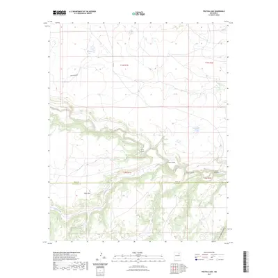
2023 Map of Frutosa Lake
USGS Topo · Published 2023About this map
The Mora River winds through a high plateau landscape defined by deep drainages and isolated water sources along the boundary of Mora County and San Miguel County. This arid upland region is punctuated by prominent geological features such as Mejan Mesa and a series of named canyons including Garza Canyon and Cañon Cibolo. The presence of Frutosa Lake, Morrison Lake, and Cabra Spring highlights the vital importance of surface water in this expansive rangeland. The map illustrates a sparse transportation network consisting of routes like Co RD 31 and Co RD C 53 A, which provide access across the rugged breaks of the Canadian River watershed. This survey captures a modern view of traditional New Mexican grazing lands where the terrain itself dictates the pattern of human movement and land use.
Find a feature on this map
19 named features on this map. Tap any name to fly to it.
Don’t see what you’re looking for? This feature index may not catch every label — zoom into the map to look around manually.
Map Details
Editions of this 2023 Frutosa Lake Map
This is the sole edition of this map. No revisions or reprints were ever made.
Other maps of this area

1892 · Watrous
USGS Topo · 1:125,000

1894 · Watrous
USGS Topo · 1:125,000

1954 · Santa Fe
USGS Topo · 1:250,000

1958 · Santa Fe
USGS Topo · 1:250,000

1964 · Frutosa Lake
USGS Topo · 1:24,000

1964 · Mogote Hills
USGS Topo · 1:24,000

1964 · Alamosa Creek
USGS Topo · 1:24,000

1964 · Canon Ancho
USGS Topo · 1:24,000
1966 · Cherry Valley Lake
USGS Topo · 1:24,000
1966 · Optimo
USGS Topo · 1:24,000