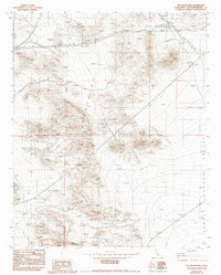
1982 Map of Fry Mountains
USGS Topo · Published 1992About this map
The Fry Mountains dominate this Mojave Desert landscape, revealing a period of focused resource extraction and high-voltage energy transmission during the late twentieth century. Industrial activity is concentrated across the slopes, characterized by an Open Pit Mine, scattered Prospects, and a labeled Mine located south of Red Hill. The terrain is defined by dry Wash channels that drain into the Upper Johnson Valley to the east. Infrastructure of the era is prominently displayed through major utility corridors, including a Double Steel Tower Transmission Line and a Single Steel Tower Transmission Line that cut through the north and central portions of the quadrangle. The map captures the specialized geography of Fry Mountain before subsequent changes in land use, documenting the precise locations of small-scale mineral exploration sites used by prospectors and mining engineers.
Find a feature on this map
11 named features on this map. Tap any name to fly to it.
Don’t see what you’re looking for? This feature index may not catch every label — zoom into the map to look around manually.
Map Details
Editions of this 1982 Fry Mountains Map
3 editions found
Other maps of this area

1901 · Southern California Sheet No. 1
USGS Topo · 1:250,000

1902 · San Gorgonio
USGS Topo · 1:125,000

1904 · Southern California Sheet No. 1
USGS Topo · 1:250,000

1947 · Lucerne Valley
USGS Topo · 1:62,500

1949 · Lucerne Valley
USGS Topo · 1:62,500

1953 · San Bernardino
USGS Topo · 1:250,000

1955 · Silver Bell Mine
USGS Topo · 1:24,000

1955 · Old Woman Springs
USGS Topo · 1:62,500

1955 · Ord Mountains
USGS Topo · 1:62,500

1955 · Rodman Mountains
USGS Topo · 1:62,500