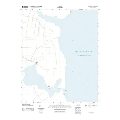
2010 Map of Frying Pan
USGS Topo · Published 2010About this map
Frying Pan and its coastal surroundings occupy this 2010 topographic representation of the Tyrrell County shoreline. The landscape is defined by the expansive waters of the Albemarle Sound, where the transition from land to water is marked by numerous named features such as Lyons Point, Catfish Point, and Orange Point. The settlement of Frying Pan itself, along with the nearby Frying Pan Landing, suggests a community historically tied to the water, likely for commerce or transit across the sound. Interior navigation and drainage are illustrated by the presence of Second Creek and Goose Creek, which meander through the low-lying terrain before reaching the sound. The presence of Crane Island and its associated Crane Island Point further highlights the coastal geography and tidal character of this North Carolina region during the early 21st century.
Find a feature on this map
15 named features on this map. Tap any name to fly to it.
Don’t see what you’re looking for? This feature index may not catch every label — zoom into the map to look around manually.
Map Details
Editions of this 2010 Frying Pan Map
This is the sole edition of this map. No revisions or reprints were ever made.
Other maps of this area

1943 · Columbia
USGS Topo · 1:125,000

1943 · Roanoke Island
USGS Topo · 1:125,000

1953 · Engelhard NW
USGS Topo · 1:24,000

1953 · Buffalo City
USGS Topo · 1:24,000

1953 · Fairfield NE
USGS Topo · 1:24,000

1953 · Columbia East
USGS Topo · 1:24,000

1953 · Scotia
USGS Topo · 1:24,000
1953 · East Lake
USGS Topo · 1:24,000

1953 · Frying Pan
USGS Topo · 1:24,000

1953 · Fairfield NW
USGS Topo · 1:24,000