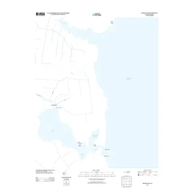
2013 Map of Frying Pan
USGS Topo · Published 2013About this map
Frying Pan and its coastal landing sit at the edge of a landscape defined by the intricate transitions of the North Carolina shoreline. This survey documents a quiet maritime environment where the Atlantic Ocean meets an array of smaller inlets and sounds. The settlement is linked to the interior by Frying Pan Rd and NC-1308, which terminate near the water at Frying Pan Landing. The local geography is marked by numerous family-named landmarks and navigational points, including Lyons Point and Catfish Point. Further south, the map details the sheltered waters of Babbitt Bay and The Straits, separated from the open sea by Crane Island. The hydrography of the region is characterized by slow-moving tributaries like Goose Cr and Second Cr, reflecting the low-lying, marshy character of the Tyrrell County coast.
Find a feature on this map
17 named features on this map. Tap any name to fly to it.
Don’t see what you’re looking for? This feature index may not catch every label — zoom into the map to look around manually.
Map Details
Editions of this 2013 Frying Pan Map
This is the sole edition of this map. No revisions or reprints were ever made.
Other maps of this area

1943 · Columbia
USGS Topo · 1:125,000

1943 · Roanoke Island
USGS Topo · 1:125,000

1953 · Engelhard NW
USGS Topo · 1:24,000

1953 · Buffalo City
USGS Topo · 1:24,000

1953 · Fairfield NE
USGS Topo · 1:24,000

1953 · Columbia East
USGS Topo · 1:24,000

1953 · Scotia
USGS Topo · 1:24,000
1953 · East Lake
USGS Topo · 1:24,000

1953 · Frying Pan
USGS Topo · 1:24,000

1953 · Fairfield NW
USGS Topo · 1:24,000