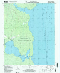
2002 Map of Frying Pan
USGS Topo · Published 2002About this map
Pocosin Lakes National Wildlife Refuge dominates this coastal landscape along the Alligator River, where the vast wetlands and low-lying peninsulas of Tyrrell County meet the water. The small settlement of Frying Pan sits at the end of Frying Pan Road, serving as a gateway to the shoreline features that define this isolated stretch of the Inner Banks. Local genealogy and community life are anchored by the Free Union Ch and a nearby Cem, indicating the long-standing presence of families in this marshy environment.
Find a feature on this map
21 named features on this map. Tap any name to fly to it.
Don’t see what you’re looking for? This feature index may not catch every label — zoom into the map to look around manually.
Map Details
Editions of this 2002 Frying Pan Map
This is the sole edition of this map. No revisions or reprints were ever made.
Other maps of this area

1943 · Columbia
USGS Topo · 1:125,000

1943 · Roanoke Island
USGS Topo · 1:125,000

1953 · Engelhard NW
USGS Topo · 1:24,000

1953 · Buffalo City
USGS Topo · 1:24,000

1953 · Fairfield NE
USGS Topo · 1:24,000

1953 · Columbia East
USGS Topo · 1:24,000

1953 · Scotia
USGS Topo · 1:24,000
1953 · East Lake
USGS Topo · 1:24,000

1953 · Frying Pan
USGS Topo · 1:24,000

1953 · Fairfield NW
USGS Topo · 1:24,000