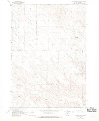
1967 Map of Ft. George Butte
USGS Topo · Published 1969About this map
The Lower Brule Indian Reservation Boundary bisects this landscape of the northern Great Plains, marking a distinct line across a region defined by its complex drainage systems. Established during a mid-1960s survey, the map details a land primarily shaped by water and elevation, notably the Ft George Butte which stands as a prominent landmark in the northeast. The terrain is deeply incised by a series of waterways, including the winding Apple Creek, Cedar Creek, and La Roche Creek. These intermittent streams create a dense network of coulees and draws that characterize the border between Stanley and Lyman counties. Evidence of ranching and land management appears through scattered infrastructure like the Flowing Well and other wells, illustrating how water sources were managed in this open environment shortly after the mid-century.
Find a feature on this map
10 named features on this map. Tap any name to fly to it.
Don’t see what you’re looking for? This feature index may not catch every label — zoom into the map to look around manually.
Map Details
Editions of this 1967 Ft. George Butte Map
This is the sole edition of this map. No revisions or reprints were ever made.
Other maps of this area

1934 · Canning
USGS Topo · 1:48,000

1937 · Canning
USGS Topo · 1:62,500

1953 · Huron
USGS Topo · 1:250,000

1954 · Pierre
USGS Topo · 1:250,000

1954 · Huron
USGS Topo · 1:250,000

1958 · Pierre
USGS Topo · 1:250,000

1966 · Ft. George Butte SE
USGS Topo · 1:24,000

1966 · Joe Creek NW
USGS Topo · 1:24,000
1966 · Joe Creek SW
USGS Topo · 1:24,000

1967 · Ft. George Butte NW
USGS Topo · 1:24,000