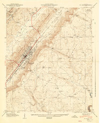
1947 Map of Ft Payne
USGS Topo · Published 1947About this map
Fort Payne sits at the heart of this post-war landscape, situated in the valley between the prominent elevations of Lookout Mountain and Shinbone Ridge. The 1946 field examination by the Tennessee Valley Authority reveals a town defined by its proximity to the Southern Railroad and its connection to the surrounding rural crossroads. To the northeast, De Soto State Park marks the edge of the plateau, while the town itself serves as a gateway to local landmarks like Manitou Cave. The map detail allows for a look at the scattered mountain communities of the era, such as Pumpkin Center and Adamsburg, where life centered around institutions like Log Cabin Chapel and numerous country burying grounds including Glenwood Cem and Sulphur Springs Cem. This survey preserves the exact settlement patterns and family-named landmarks of De Kalb County before mid-century expansion.
Find a feature on this map
64 named features on this map. Tap any name to fly to it.
Don’t see what you’re looking for? This feature index may not catch every label — zoom into the map to look around manually.
Map Details
Editions of this 1947 Ft Payne Map
2 editions found
Other maps of this area

1886 · Stevenson
USGS Topo · 1:125,000

1892 · Stevenson
USGS Topo · 1:125,000

1893 · Fort Payne
USGS Topo · 1:125,000

1895 · Stevenson
USGS Topo · 1:125,000

1898 · Fort Payne
USGS Topo · 1:125,000

1900 · Fort Payne
USGS Topo · 1:125,000

1936 · Dugout Valley
USGS Topo · 1:24,000

1936 · Chavies
USGS Topo · 1:24,000

1936 · Sylvania
USGS Topo · 1:24,000
1936 · Little Falls
USGS Topo · 1:24,000