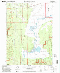
1998 Map of Fuego
USGS Topo · Published 2000About this map
Klamath Marsh and its surrounding wetlands dominate this landscape at the turn of the millennium, where the Williamson River meanders through a complex network of ditches and natural channels. The area serves as a critical hydrological junction, evidenced by the Klamath Marsh National Wildlife Refuge and the managed flow of the Soloman Ditch. Small settlements such as Kirk and Chinchalo mark the rail and road corridors, while the name Fuego appears near the center of the sheet, reflecting the local history of these remote outposts. To the west, the terrain shifts into the Antelope Desert, a sharp contrast to the riparian zones of the river. The map also captures infrastructure including a prominent north-south Pipeline and the Silver Lake Road, illustrating how human development follows the natural contours of the Winema National Forest borderlands.
Find a feature on this map
20 named features on this map. Tap any name to fly to it.
Don’t see what you’re looking for? This feature index may not catch every label — zoom into the map to look around manually.
Map Details
Editions of this 1998 Fuego Map
This is the sole edition of this map. No revisions or reprints were ever made.
Other maps of this area

1889 · Klamath
USGS Topo · 1:250,000

1894 · Klamath
USGS Topo · 1:250,000

1955 · Klamath Falls
USGS Topo · 1:250,000

1956 · Calimus Butte
USGS Topo · 1:62,500

1957 · Chiloquin
USGS Topo · 1:62,500

1957 · Klamath Marsh
USGS Topo · 1:62,500

1957 · Lenz
USGS Topo · 1:62,500

1958 · Klamath Falls
USGS Topo · 1:250,000

1980 · Williamson River
USGS Topo · 1:100,000
1985 · Pothole Butte
USGS Topo · 1:24,000