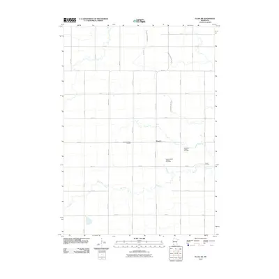
2010 Map of Fulda SW
USGS Topo · Published 2010About this map
The rural agricultural landscape surrounding Pfingsten in Nobles County is defined by a rigorous section-line road grid and an extensive network of managed waterways. This 2010 survey illustrates the sophisticated drainage systems vital to southwestern Minnesota farming, including County Ditch Number Eighty, Judicial Ditch Number Twenty, and Judicial Ditch Number Twelve. These man-made channels intersect with natural drainage like Jack Creek, which meanders across the southern portion of the quadrangle. For those researching local heritage, the map identifies significant landmarks such as the American Lutheran Cemetery and Seward Cemetery. The inclusion of water management features like the Desiltation Project 73-2 Dam and Kremer-Leiner-Goedtke Pond Dam reflects modern conservation efforts integrated into the longstanding prairie farmstead layout, where family names often persist in the labeling of local infrastructure.
Find a feature on this map
32 named features on this map. Tap any name to fly to it.
Don’t see what you’re looking for? This feature index may not catch every label — zoom into the map to look around manually.
Map Details
Editions of this 2010 Fulda SW Map
This is the sole edition of this map. No revisions or reprints were ever made.
Other maps of this area

1954 · Fairmont
USGS Topo · 1:250,000

1958 · Fairmont
USGS Topo · 1:250,000

1960 · Reading
USGS Topo · 1:24,000

1960 · Worthington North
USGS Topo · 1:24,000

1967 · Slayton
USGS Topo · 1:24,000

1967 · Wilmont
USGS Topo · 1:24,000

1967 · Adrian NE
USGS Topo · 1:24,000

1970 · Fulda
USGS Topo · 1:24,000
1970 · Fulda SW
USGS Topo · 1:24,000
1970 · Lime Creek
USGS Topo · 1:24,000