
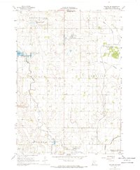
1967 Map of Slayton
USGS Topo · Published 1968About this map
Slayton serves as the regional hub for this prairie landscape, where two major rail lines intersect at the height of the mid-century agricultural era. The Chicago and North Western passes through the northern edge near Hadley, while the Chicago Milwaukee St Paul and Pacific crosses through Iona in the south. This transport network supported a landscape of small local institutions, from West Sch and School No 1281 to the St Columba Cem. To the west, the glacial topography is marked by Summit Lake and Corabelle Lake, while the Schoeberl State Wildlife Management Area highlights the conservation of local habitat amidst the surrounding township grids. The presence of a Drive-in Theater and the Slayton Municipal Airport near the town center reflect the post-war development and modern recreation typical of the 1960s.
Find a feature on this map
21 named features on this map. Tap any name to fly to it.
Don’t see what you’re looking for? This feature index may not catch every label — zoom into the map to look around manually.
Map Details
Editions of this 1967 Slayton Map
This is the sole edition of this map. No revisions or reprints were ever made.
Other maps of this area

1953 · New Ulm
USGS Topo · 1:250,000

1954 · Fairmont
USGS Topo · 1:250,000

1957 · New Ulm
USGS Topo · 1:250,000

1958 · New Ulm
USGS Topo · 1:250,000

1958 · Fairmont
USGS Topo · 1:250,000

1967 · New Ulm
USGS Topo · 1:250,000

1967 · Slayton SW
USGS Topo · 1:24,000
1967 · Balaton SW
USGS Topo · 1:24,000

1967 · Wilmont
USGS Topo · 1:24,000

1967 · Hadley
USGS Topo · 1:24,000