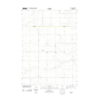
2013 Map of Fulda SW
USGS Topo · Published 2013About this map
Pfingsten marks a central point in this prairie landscape, where the agricultural grid of Nobles and Murray counties meets the subtle rise of the Coteau des Prairies. This 2013 survey illustrates the highly managed water systems of the region, featuring County Ditch Number Eighty and several judicial ditches designed to drain the land for intensive farming. The winding path of Jack Cr provides a natural contrast to the straight-line irrigation and road network. Genealogists and local historians can locate the American Lutheran Cem and Seward Cem, which serve as quiet landmarks of the area's rural settlement history. The map's detailed road labels, including McCall Ave and Monroe Ave, trace the established section lines that have defined this corner of Minnesota for generations.
Find a feature on this map
30 named features on this map. Tap any name to fly to it.
Don’t see what you’re looking for? This feature index may not catch every label — zoom into the map to look around manually.
Map Details
Editions of this 2013 Fulda SW Map
This is the sole edition of this map. No revisions or reprints were ever made.
Other maps of this area

1954 · Fairmont
USGS Topo · 1:250,000

1958 · Fairmont
USGS Topo · 1:250,000

1960 · Reading
USGS Topo · 1:24,000

1960 · Worthington North
USGS Topo · 1:24,000

1967 · Slayton
USGS Topo · 1:24,000

1967 · Wilmont
USGS Topo · 1:24,000

1967 · Adrian NE
USGS Topo · 1:24,000

1970 · Fulda
USGS Topo · 1:24,000
1970 · Fulda SW
USGS Topo · 1:24,000
1970 · Lime Creek
USGS Topo · 1:24,000