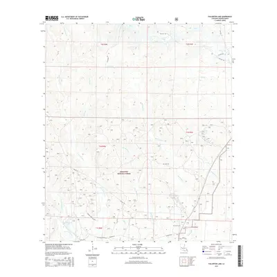
2015 Map of Fullerton Lake
USGS Topo · Published 2015About this map
Kisatchie National Forest defines the landscape of this Vernon Parish region, where dense drainage networks converge into Fullerton Lake. The terrain is characterized by a complex system of creeks and branches, including the winding Big Brushy Cr and the Thompson Br. This 2015 data reflects a heavily managed timber and conservation environment, crisscrossed by specialized routes like Lookout Rd and Forestry Service Rd 492J. Local history and genealogy interests are represented by family-named landmarks such as Smith Cem and Semon Cem, which persist alongside older transit corridors like Fullerton Blacktop Rd. The map illustrates the convergence of several township boundaries, including t1n r5w and t1n r6w, marking the administrative divisions of this wooded Louisiana interior.
Find a feature on this map
27 named features on this map. Tap any name to fly to it.
Don’t see what you’re looking for? This feature index may not catch every label — zoom into the map to look around manually.
Map Details
Editions of this 2015 Fullerton Lake Map
This is the sole edition of this map. No revisions or reprints were ever made.
Other maps of this area

1941 · Slagle
USGS Topo · 1:62,500

1943 · Leander
USGS Topo · 1:62,500

1944 · Slagle
USGS Topo · 1:62,500

1947 · Steep Gully
USGS Topo · 1:31,680

1947 · Sugrue
USGS Topo · 1:31,680

1947 · Pitkin
USGS Topo · 1:31,680
1951 · Pitkin
USGS Topo · 1:24,000

1951 · Steep Gully
USGS Topo · 1:24,000

1952 · Lake Charles
USGS Topo · 1:250,000

1953 · Alexandria
USGS Topo · 1:250,000