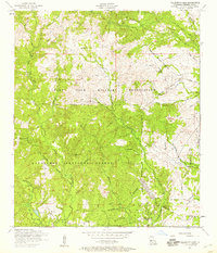
1954 Map of Fullerton Lake
USGS Topo · Published 1959About this map
Kisatchie National Forest and the Fort Polk Military Reservation dominate this mid-century landscape in Vernon Parish, where industrial history is still etched into the terrain. The presence of several stretches of Dismantled railroad indicates a legacy of timber harvesting or military logistics that once traversed these wooded hills. Near the southern edge, the settlement of Fullerton sits adjacent to Fullerton Lake, serving as a focal point for local activity alongside the Fullerton Lookout Tower. Genealogists and local historians can locate family landmarks such as the Oak Grove Church and the Sermon Cemetery or Smith Cemetery, which are tucked away near the winding paths of Big Brushy Creek and East Fork Sixmile Creek. The map provides a detailed view of the transitional period when former rail lines were giving way to forest management and military utility.
Find a feature on this map
18 named features on this map. Tap any name to fly to it.
Don’t see what you’re looking for? This feature index may not catch every label — zoom into the map to look around manually.
Map Details
Editions of this 1954 Fullerton Lake Map
This is the sole edition of this map. No revisions or reprints were ever made.
Other maps of this area

1941 · Slagle
USGS Topo · 1:62,500

1943 · Leander
USGS Topo · 1:62,500

1944 · Slagle
USGS Topo · 1:62,500

1947 · Steep Gully
USGS Topo · 1:31,680

1947 · Sugrue
USGS Topo · 1:31,680

1947 · Pitkin
USGS Topo · 1:31,680
1951 · Pitkin
USGS Topo · 1:24,000

1951 · Steep Gully
USGS Topo · 1:24,000

1952 · Lake Charles
USGS Topo · 1:250,000

1953 · Alexandria
USGS Topo · 1:250,000