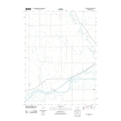
2011 Map of Fullerton NE
USGS Topo · Published 2011About this map
Loup River and its accompanying Loup River Canal dominate the southern portion of this Nance County landscape, where the Loup Diversion Dam manages the flow of the waterways. This rural expanse near Krakow is defined by a dense network of drainage, including the winding paths of Beaver Creek, Skeedee Creek, and Council Creek. The map provides a detailed record of section-line roads and rural infrastructure in the early 21st century. Genealogists will find the Sunnyside Cemetery located west of the main river junction, while researchers of local geography can trace the small tributaries like Plum Creek as they feed into the larger river system. The presence of Minimum M Rd and other local routes illustrates the grid-based settlement pattern that persists in this Nebraska agricultural region.
Find a feature on this map
10 named features on this map. Tap any name to fly to it.
Don’t see what you’re looking for? This feature index may not catch every label — zoom into the map to look around manually.
Map Details
Editions of this 2011 Fullerton NE Map
This is the sole edition of this map. No revisions or reprints were ever made.
Other maps of this area

1896 · Stromsburg
USGS Topo · 1:125,000

1955 · Fremont
USGS Topo · 1:250,000

1957 · Fremont
USGS Topo · 1:250,000

1958 · Fremont
USGS Topo · 1:250,000

1958 · Genoa
USGS Topo · 1:24,000
1958 · Merchiston
USGS Topo · 1:24,000

1958 · Fullerton
USGS Topo · 1:24,000

1958 · Fullerton NE
USGS Topo · 1:24,000

1958 · Silver Creek
USGS Topo · 1:24,000

1958 · Havens
USGS Topo · 1:24,000