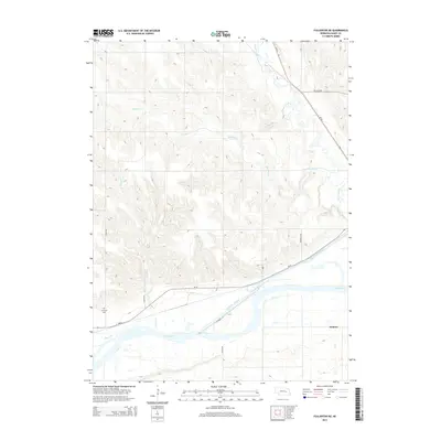
2014 Map of Fullerton NE
USGS Topo · Published 2014About this map
Krakow sits at the eastern edge of this Nebraska landscape, where the agricultural plains meet a complex network of waterways. The southern portion of the sheet is defined by the parallel courses of the Loup River and the Loup River Canal, a significant piece of regional water infrastructure. This corridor is further intersected by Council Cr and Plum Cr, illustrating the hydrological density required to support the local farming economy. To the north, the terrain is carved by the winding paths of Beaver Creek and Skeedee Cr, which meander through the sections toward the Loup valley. Transportation is anchored by Ne-22 and Ne-39, providing the primary links between the scattered farmsteads and the smaller community hubs. Genealogists and local historians will find the location of Sunnyside Cem in the southwestern quadrant, a quiet marker of the families who settled this Nance County territory.
Find a feature on this map
16 named features on this map. Tap any name to fly to it.
Don’t see what you’re looking for? This feature index may not catch every label — zoom into the map to look around manually.
Map Details
Editions of this 2014 Fullerton NE Map
This is the sole edition of this map. No revisions or reprints were ever made.
Other maps of this area

1896 · Stromsburg
USGS Topo · 1:125,000

1955 · Fremont
USGS Topo · 1:250,000

1957 · Fremont
USGS Topo · 1:250,000

1958 · Fremont
USGS Topo · 1:250,000

1958 · Genoa
USGS Topo · 1:24,000
1958 · Merchiston
USGS Topo · 1:24,000

1958 · Fullerton
USGS Topo · 1:24,000

1958 · Fullerton NE
USGS Topo · 1:24,000

1958 · Silver Creek
USGS Topo · 1:24,000

1958 · Havens
USGS Topo · 1:24,000