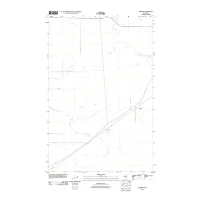
2010 Map of Funkley
USGS Topo · Published 2010About this map
The small settlements of Funkley and Shooks anchor this portion of Beltrami County, highlighting a rural landscape defined by the drainage of the North Cormorant River and South Cormorant River. In the northern section, Shooks sits at a highway junction, while Funkley is positioned further south along the prominent diagonal of the Blue Ox Trl. This trail, a significant corridor through the region, passes through Houpt as it cuts across the township lines of TWP 30. The terrain is marked by seasonal watercourses and wetlands, including Perry Creek, which feeds into the larger river systems. Local travel is facilitated by a network of secondary routes like 6-Mile Rd and County Hwy-304, which connect these isolated outposts within the northern Minnesota woods. The map illustrates the quiet persistence of these small communities in a landscape where water and timber routes shaped the original patterns of settlement.
Find a feature on this map
12 named features on this map. Tap any name to fly to it.
Don’t see what you’re looking for? This feature index may not catch every label — zoom into the map to look around manually.
Map Details
Editions of this 2010 Funkley Map
This is the sole edition of this map. No revisions or reprints were ever made.
Other maps of this area

1919 · Rosy
USGS Topo · 1:62,500

1919 · Quiring
USGS Topo · 1:62,500

1919 · Bridgie
USGS Topo · 1:62,500

1924 · Bridgie
USGS Topo · 1:62,500

1954 · Bemidji
USGS Topo · 1:250,000

1957 · Bemidji
USGS Topo · 1:250,000

1958 · Bemidji
USGS Topo · 1:250,000

1971 · Funkley
USGS Topo · 1:24,000

1971 · Decker Lake
USGS Topo · 1:24,000
1971 · Kelliher
USGS Topo · 1:24,000