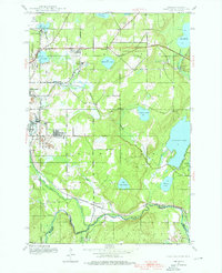
1944 Map of Gaastra
USGS Topo · Published 1976About this map
Mining operations and iron-ore logistics define the landscape of this mid-century survey along the Michigan and Wisconsin border. Dense networks of the Chicago and Northwestern and the Chicago Milwaukee St Paul and Pacific railroads crisscross the terrain to service industrial sites like the Bates Mine, Rogers Mine, and Bengal Mine. These extraction points are the core of local settlements such as Gaastra, Caspian, and Palatka, where residential clusters sit adjacent to the workings.
Find a feature on this map
35 named features on this map. Tap any name to fly to it.
Don’t see what you’re looking for? This feature index may not catch every label — zoom into the map to look around manually.
Map Details
Editions of this 1944 Gaastra Map
2 editions found
Other maps of this area

1898 · Iron River
USGS Topo · 1:62,500

1899 · Crystal Falls
USGS Topo · 1:62,500

1939 · Long Lake
USGS Topo · 1:48,000

1941 · Florence
USGS Topo · 1:48,000

1944 · Iron River
USGS Topo · 1:24,000

1944 · Gaastra
USGS Topo · 1:24,000

1944 · Fortune Lakes
USGS Topo · 1:24,000

1945 · Gibbs City
USGS Topo · 1:24,000

1945 · Sunset Lake
USGS Topo · 1:24,000

1945 · Amasa
USGS Topo · 1:24,000