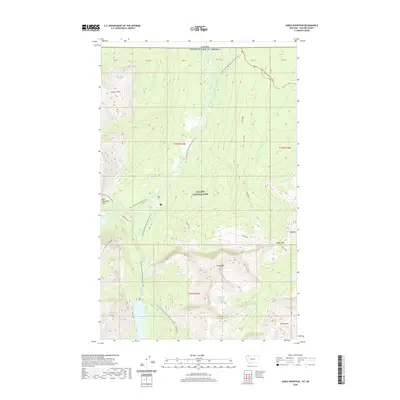
2020 Map of Gable Mountain
USGS Topo · Published 2020About this map
Glacier National Park dominates this high-altitude landscape along the border of the United States and Canada. The terrain is defined by a network of significant waterways and peaks, including the Belly River and the Mokowanis River which converge in the northern reaches of the park. Hikers and researchers can trace the path of the Continental Divide National Scenic Trail and the Pacific NW National Scenic Trail as they navigate the ridges and valleys between Gable Mtn and Sentinel Mtn. The map highlights remote backcountry points of interest such as the Bear Mountain Lookout and numerous alpine water features like Elizabeth Lake, Otatso Lake, and the cascade at Gros Ventre Falls. The Chief Mountain Highway cuts through the northeastern corner, providing a rare vehicular corridor in this otherwise wild environment of steep massifs like Lee Ridge and Cosley Ridge.
Find a feature on this map
27 named features on this map. Tap any name to fly to it.
Don’t see what you’re looking for? This feature index may not catch every label — zoom into the map to look around manually.
Map Details
Editions of this 2020 Gable Mountain Map
This is the sole edition of this map. No revisions or reprints were ever made.
Other maps of this area

1904 · Chief Mountain
USGS Topo · 1:125,000

1938 · Chief Mountain
USGS Topo · 1:125,000

1960 · Cut Bank
USGS Topo · 1:250,000

1963 · Cut Bank
USGS Topo · 1:250,000

1964 · Cut Bank
USGS Topo · 1:250,000

1968 · Ahern Pass
USGS Topo · 1:24,000

1968 · Gable Mountain
USGS Topo · 1:24,000
1968 · Mount Cleveland
USGS Topo · 1:24,000
1968 · Chief Mountain
USGS Topo · 1:24,000
1968 · Lake Sherburne
USGS Topo · 1:24,000