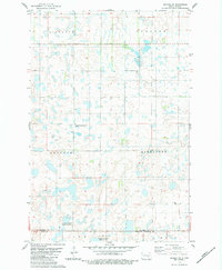
1983 Map of Gackle NE
USGS Topo · Published 1984About this map
Glacial prairie potholes and marshy wetlands dominate this landscape in Stutsman and Logan counties, where the terrain is organized by established civil townships. Small-scale human markers are clustered near the center of the sheet, including a lonely Cem and the Seventh Day Adventist Cem located near the intersection of township lines. The map reveals the township structure of Sinclair, Cussator, Griffin, Alexander, Finn, and Glen, providing a record of the political boundaries and land divisions of the era. This area, largely free of major towns or rail lines, shows the persistence of a sparsely populated agrarian landscape where water management and field boundaries define the local geography. A single Gravel Pit in the southeastern portion of the quadrangle hints at local road maintenance or infrastructure needs in this late-twentieth-century rural setting.
Find a feature on this map
9 named features on this map. Tap any name to fly to it.
Don’t see what you’re looking for? This feature index may not catch every label — zoom into the map to look around manually.
Map Details
Editions of this 1983 Gackle NE Map
This is the sole edition of this map. No revisions or reprints were ever made.
Other maps of this area

1896 · Jamestown
USGS Topo · 1:125,000

1952 · Jud NW
USGS Topo · 1:24,000

1952 · Eldridge SW
USGS Topo · 1:24,000

1953 · Jamestown
USGS Topo · 1:250,000

1953 · Cleveland SE
USGS Topo · 1:24,000

1953 · Jud
USGS Topo · 1:24,000

1953 · Cleveland SW
USGS Topo · 1:24,000

1956 · Jamestown
USGS Topo · 1:250,000

1983 · Alfred
USGS Topo · 1:24,000

1983 · Gackle North
USGS Topo · 1:24,000