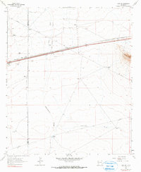
1963 Map of Gage NW
USGS Topo · Published 1990About this map
The Continental Divide cuts a diagonal path across this high desert landscape, marking the hydrological split in the southwestern corner of New Mexico. In the early 1960s, this area of Luna and Grant counties was defined by the industrial presence of the Southern Pacific railroad, which parallels a major two-lane road. The small siding at Wilna serves as a central landmark for a region primarily used for ranching and resource extraction, as evidenced by numerous Borrow Pits and gravel operations. Sparse settlement is limited to remote outposts like Tilch Ranch, Baker Ranch, and Parker Ranch. The terrain rises sharply to the east at the Victorio Mtns, with Gage Mtn 5114 standing as a prominent local peak. Water management is critical in this arid environment, traced through a network of windmills and named catchments such as Briar Hill Tank and Pipeline Tank.
Find a feature on this map
24 named features on this map. Tap any name to fly to it.
Don’t see what you’re looking for? This feature index may not catch every label — zoom into the map to look around manually.
Map Details
Editions of this 1963 Gage NW Map
2 editions found
Other maps of this area

1954 · Silver City
USGS Topo · 1:250,000

1958 · Silver City
USGS Topo · 1:250,000

1962 · Silver City
USGS Topo · 1:250,000

1963 · Gage SW
USGS Topo · 1:24,000

1963 · Soldiers Farewell Hill
USGS Topo · 1:24,000

1963 · Gage NW
USGS Topo · 1:24,000

1963 · Gage
USGS Topo · 1:24,000
1963 · Grandmother Mountain West
USGS Topo · 1:24,000
1963 · Gage SE
USGS Topo · 1:24,000
1964 · The Saltys
USGS Topo · 1:24,000