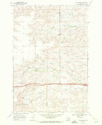
1969 Map of Gails Coulee
USGS Topo · Published 1972About this map
Gails Coulee and the surrounding drainage basins of south-central Montana are defined by a network of intermittent streams and natural water sources. In the late 1960s, this landscape straddling the Yellowstone Co Big Horn Co line remained largely undeveloped, characterized by the winding paths of Tenmile Creek and Barley Coulee. A notable human addition to the terrain is the Landing Strip located north of the Base Line, indicating the importance of small-scale aviation for reaching this area of the high plains. The map also captures the local hydrography through features like Alkali Spring and Hay Creek, reflecting the importance of water management in a region where reliable springs were critical for livestock and land use. The southern portion of the sheet is bisected by a major highway corridor, featuring a designated Rest Area near the county boundary.
Find a feature on this map
11 named features on this map. Tap any name to fly to it.
Don’t see what you’re looking for? This feature index may not catch every label — zoom into the map to look around manually.
Map Details
Editions of this 1969 Gails Coulee Map
This is the sole edition of this map. No revisions or reprints were ever made.
Other maps of this area

1893 · Huntley
USGS Topo · 1:125,000

1894 · Fort Custer
USGS Topo · 1:125,000

1954 · Billings
USGS Topo · 1:250,000

1954 · Hardin
USGS Topo · 1:250,000

1957 · Hardin
USGS Topo · 1:250,000

1957 · Billings
USGS Topo · 1:250,000

1958 · Billings
USGS Topo · 1:250,000

1958 · Hardin
USGS Topo · 1:250,000

1967 · Nibbe
USGS Topo · 1:24,000

1967 · Worden
USGS Topo · 1:24,000