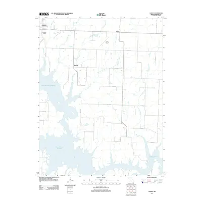
2011 Map of Gaines
USGS Topo · Published 2011About this map
Harry S Truman Reservoir dominates the southwestern quadrant of this Henry County landscape, where the rising waters of the lake have permanently altered the local drainage patterns. The map documents the intricate interface between the reservoir's fingers and the established rural road network, which transitions from named suburban routes like N Vansant Rd near the edge of Clinton to a rigid section-line grid in the eastern plains. Small rural clusters and geographic points such as Sparrow, Alberta, and Gaines serve as anchors for the surrounding agricultural community. The terrain is defined by a series of south-flowing tributaries, including Pretty Bob Creek and Sparrow Foot Creek, which feed into the primary reservoir basin. Aviation and local history are represented by the Clinton Memorial Airport and the sprawling Englewood Cemetery, both situated on the northern fringes of the survey area.
Find a feature on this map
46 named features on this map. Tap any name to fly to it.
Don’t see what you’re looking for? This feature index may not catch every label — zoom into the map to look around manually.
Map Details
Editions of this 2011 Gaines Map
This is the sole edition of this map. No revisions or reprints were ever made.
Other maps of this area

1887 · Clinton
USGS Topo · 1:125,000

1894 · Clinton
USGS Topo · 1:125,000

1941 · Valhalla
USGS Topo · 1:24,000

1941 · Lowry City
USGS Topo · 1:24,000

1945 · Lowry City
USGS Topo · 1:24,000
1945 · Valhalla
USGS Topo · 1:24,000

1947 · Jefferson City
USGS Topo · 1:250,000

1953 · Gaines
USGS Topo · 1:24,000
1953 · Calhoun East
USGS Topo · 1:24,000

1953 · Clinton South
USGS Topo · 1:24,000