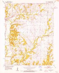
1953 Map of Calhoun East
USGS Topo · Published 1955About this map
Calhoun sits at the northwestern edge of this 1950s survey, where the Missouri Kansas Texas railroad cuts through the prairie landscape of western Missouri. The terrain is defined by the dendritic drainage patterns of Tebo Creek and its many tributaries, including Middle Fork, East Fork, and Barker Creek. This area of Henry County is characterized by a dense network of rural infrastructure, suggesting a vibrant mid-century farming community.
Find a feature on this map
30 named features on this map. Tap any name to fly to it.
Don’t see what you’re looking for? This feature index may not catch every label — zoom into the map to look around manually.
Map Details
Editions of this 1953 Calhoun East Map
2 editions found
Other maps of this area

1885 · Warrensburg
USGS Topo · 1:125,000

1887 · Clinton
USGS Topo · 1:125,000

1887 · Sedalia
USGS Topo · 1:125,000

1887 · Warsaw
USGS Topo · 1:125,000

1887 · Warrensburg
USGS Topo · 1:125,000

1894 · Warsaw
USGS Topo · 1:125,000

1894 · Sedalia
USGS Topo · 1:125,000

1894 · Warrensburg
USGS Topo · 1:125,000

1894 · Clinton
USGS Topo · 1:125,000

1936 · Shawnee Bend
USGS Topo · 1:24,000