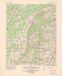
1940 Map of Gainesville
USGS Topo · Published 1948About this map
Jones Ridge rises above the alluvial bottomlands of the Cache River in this detailed survey of northeast Arkansas. The landscape is defined by an intricate network of drainage features like Petersburg Ditch, Gum Slough, and the Main Canal, reflecting the massive efforts to manage water for the region's agriculture. Small rural communities such as Beech Grove, Stanford, and Delaplaine anchor the township grid, each supported by a high density of neighborhood institutions. The map reveals an incredible concentration of dual-purpose sites like Pine Knot Ch Sch & Cem and Commissary Ch & Sch, which served as the spiritual and educational hubs for farming families. To the south, the topography shifts at Crowley Ridge State Park, while the eastern portion of the sheet shows the growth of Gainesville and the outskirts of the county seat.
Find a feature on this map
70 named features on this map. Tap any name to fly to it.
Don’t see what you’re looking for? This feature index may not catch every label — zoom into the map to look around manually.
Map Details
Editions of this 1940 Gainesville Map
2 editions found
Other maps of this area

1932 · Walnut Ridge
USGS Topo · 1:62,500

1935 · Sedgwick
USGS Topo · 1:62,500

1935 · Rector
USGS Topo · 1:62,500

1935 · Knobel
USGS Topo · 1:62,500

1935 · Reyno
USGS Topo · 1:62,500

1935 · Walnut Ridge
USGS Topo · 1:62,500

1939 · Jonesboro
USGS Topo · 1:62,500

1940 · Gainesville
USGS Topo · 1:62,500

1940 · Marmaduke
USGS Topo · 1:62,500

1941 · Leachville
USGS Topo · 1:62,500