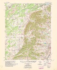
1960 Map of Gainesville
USGS Topo · Published 1960About this map
Crowleys Ridge rises above the flatlands of the Delta in this 1958 topographic survey of northeast Arkansas, revealing a landscape defined by dramatic geological shifts and extensive hydraulic engineering. To the west, the Cache River bottomlands are heavily modified by an intricate network of drainage systems, including the Petersburg Ditch, Main Canal, and numerous numbered laterals that supported the region's agricultural expansion. This area is anchored by the settlement of Delaplaine and the Missouri Pacific railroad line.
Find a feature on this map
83 named features on this map. Tap any name to fly to it.
Don’t see what you’re looking for? This feature index may not catch every label — zoom into the map to look around manually.
Map Details
Editions of this 1960 Gainesville Map
This is the sole edition of this map. No revisions or reprints were ever made.
Other maps of this area

1932 · Walnut Ridge
USGS Topo · 1:62,500

1935 · Sedgwick
USGS Topo · 1:62,500

1935 · Rector
USGS Topo · 1:62,500

1935 · Knobel
USGS Topo · 1:62,500

1935 · Reyno
USGS Topo · 1:62,500

1935 · Walnut Ridge
USGS Topo · 1:62,500

1939 · Jonesboro
USGS Topo · 1:62,500

1940 · Gainesville
USGS Topo · 1:62,500

1940 · Marmaduke
USGS Topo · 1:62,500

1941 · Leachville
USGS Topo · 1:62,500