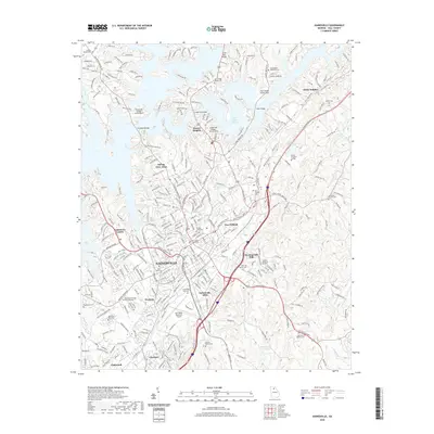
2020 Map of Gainesville
USGS Topo · Published 2020About this map
Gainesville serves as the focal point of this North Georgia landscape, where the urban street grid of the county seat meets the expansive waters of Lake Sidney Lanier. The map documents a complex mix of historic institutional sites and modern suburban growth, from the downtown Hall County Courthouse and Brenau University campus to industrial corridors at Gainesville Mills and Chicopee. A significant number of local landmarks and genealogical sites are present, including Alta Vista Cem, New Holland Cem, and the Memorial Park Cem. North of the city, the flooded valley of the Chattahoochee River is navigated by several crossings like Bells Mill Bridge and Longstreet Bridge Access Point, reflecting the region's mid-century transformation into a major recreational and residential destination. Smaller settlements like White Sulphur, Oakwood, and New Holland dot the surrounding terrain, connected by a dense network of roads and the Lee Gilmer Memorial Airport.
Find a feature on this map
312 named features on this map. Tap any name to fly to it.
Don’t see what you’re looking for? This feature index may not catch every label — zoom into the map to look around manually.
Map Details
Editions of this 2020 Gainesville Map
This is the sole edition of this map. No revisions or reprints were ever made.
Other maps of this area

1891 · Gainesville
USGS Topo · 1:125,000

1954 · Greenville
USGS Topo · 1:250,000

1958 · Greenville
USGS Topo · 1:250,000

1964 · Murrayville
USGS Topo · 1:24,000

1964 · Chestnut Mountain
USGS Topo · 1:24,000

1964 · Lula
USGS Topo · 1:24,000

1964 · Gainesville
USGS Topo · 1:24,000
1964 · Chestatee
USGS Topo · 1:24,000

1964 · Pendergrass
USGS Topo · 1:24,000
1964 · Flowery Branch
USGS Topo · 1:24,000