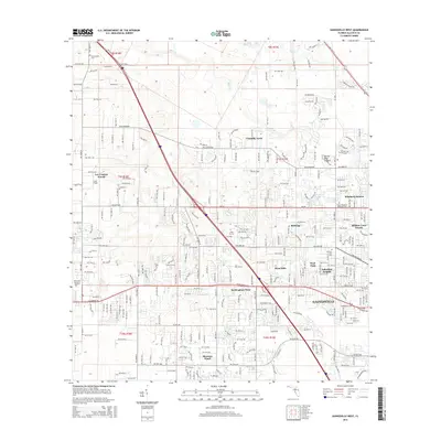
2015 Map of Gainesville West
USGS Topo · Published 2015About this map
Gainesville expands westward in this 2015 update, showcasing the established residential patterns of Alachua County. The map details a transition from the urban core toward suburban developments like Suburban Heights, Buckingham West, and Shannon Wood. A significant local landmark, the Devils Mill Hopper geological formation, sits near the intersection of Millhopper Rd and NW 43rd St, marking the edge of the more developed city landscape.
Find a feature on this map
152 named features on this map. Tap any name to fly to it.
Don’t see what you’re looking for? This feature index may not catch every label — zoom into the map to look around manually.
Map Details
Editions of this 2015 Gainesville West Map
This is the sole edition of this map. No revisions or reprints were ever made.
Other maps of this area

1890 · Arredondo
USGS Topo · 1:62,500

1892 · Arredondo
USGS Topo · 1:62,500

1894 · Arredondo
USGS Topo · 1:62,500

1954 · Gainesville
USGS Topo · 1:250,000

1958 · Gainesville
USGS Topo · 1:250,000

1959 · Gainesville
USGS Topo · 1:250,000

1962 · High Springs
USGS Topo · 1:24,000
1966 · Micanopy
USGS Topo · 1:24,000

1966 · Gainesville West
USGS Topo · 1:24,000

1966 · Arredondo
USGS Topo · 1:24,000