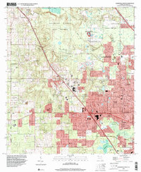
1994 Map of Gainesville West
USGS Topo · Published 2000About this map
San Felasco Hammock State Preserve dominates the northwestern landscape, preserving a massive limestone-rich woodland before it gives way to the suburban expansion of western Alachua County. This mid-1990s survey illustrates the distinct boundary between the wild terrain of Sanchez Prairie and the rapidly developing neighborhoods like Chantilly Acres, West Hills, and Shannon Wood. The geography is defined by significant karst features, most notably the Devils Mill Hopper State Geological Site, a deep sinkhole that serves as a focal point for local geological study.
Find a feature on this map
53 named features on this map. Tap any name to fly to it.
Don’t see what you’re looking for? This feature index may not catch every label — zoom into the map to look around manually.
Map Details
Editions of this 1994 Gainesville West Map
This is the sole edition of this map. No revisions or reprints were ever made.
Other maps of this area

1890 · Arredondo
USGS Topo · 1:62,500

1892 · Arredondo
USGS Topo · 1:62,500

1894 · Arredondo
USGS Topo · 1:62,500

1954 · Gainesville
USGS Topo · 1:250,000

1958 · Gainesville
USGS Topo · 1:250,000

1959 · Gainesville
USGS Topo · 1:250,000

1962 · High Springs
USGS Topo · 1:24,000
1966 · Micanopy
USGS Topo · 1:24,000

1966 · Gainesville West
USGS Topo · 1:24,000

1966 · Arredondo
USGS Topo · 1:24,000