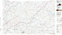
1986 Map of Galax
USGS Topo · Published 1986About this map
The Blue Ridge Parkway winds across the high crests of the Blue Ridge Mountains in this mid-1980s look at the Virginia and North Carolina borderlands. From the industrial hub of Galax and the county seat at Hillsville to the educational grounds of Ferrum Jr College, the map illustrates a landscape of mountain farming and emerging recreation. The drainage systems are particularly complex, with the New River and Little Reed Island Creek carving deep valleys on the western slope, while the Dan River and Ararat River begin their descent toward the Piedmont to the south and east.
Find a feature on this map
390 named features on this map. Tap any name to fly to it.
Don’t see what you’re looking for? This feature index may not catch every label — zoom into the map to look around manually.
Map Details
Editions of this 1986 Galax Map
2 editions found
Other maps of this area

1887 · Pocahontas
USGS Topo · 1:125,000

1889 · Hillsville
USGS Topo · 1:125,000

1889 · Wytheville
USGS Topo · 1:125,000

1889 · Wilkesboro
USGS Topo · 1:125,000

1890 · Roanoke
USGS Topo · 1:125,000

1890 · Dublin
USGS Topo · 1:125,000

1890 · Christiansburg
USGS Topo · 1:125,000

1891 · Roanoke
USGS Topo · 1:125,000

1891 · Pocahontas
USGS Topo · 1:125,000

1891 · Dublin
USGS Topo · 1:125,000