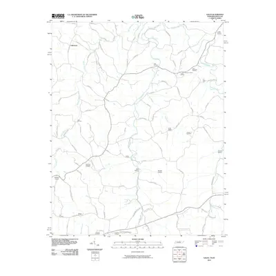
2010 Map of Galen
USGS Topo · Published 2010About this map
Underwood and Salt Lick anchor a landscape defined by deeply incised drainages and a dense network of country roads along the Tennessee-Kentucky border. The terrain is characterized by numerous hollows, including Bradley Hollow and Ellis Hollow, where small family-named landmarks suggest long-standing community ties. Genealogists will find this map particularly useful for its high concentration of family burial grounds. Notable sites like the Frog Pond-Friendship Cemetery, John Brandon Cemetery, and Elias McDonald Cemetery are clearly marked. The hydrological network is dominated by the Long Fork and the White Oak Creek, which dictate the local topography. This early 21st-century survey reflects the persistent rural character of the region, where transportation routes like Antioch Rd and Liberty Rd continue to follow the natural contours of the ridges and valleys.
Find a feature on this map
90 named features on this map. Tap any name to fly to it.
Don’t see what you’re looking for? This feature index may not catch every label — zoom into the map to look around manually.
Map Details
Editions of this 2010 Galen Map
This is the sole edition of this map. No revisions or reprints were ever made.
Other maps of this area

1931 · Lafayette
USGS Topo · 1:62,500

1931 · Red Boiling Springs
USGS Topo · 1:62,500

1932 · Carthage
USGS Topo · 1:62,500

1954 · Fountain Run
USGS Topo · 1:24,000

1954 · Gamaliel
USGS Topo · 1:24,000

1954 · Holland
USGS Topo · 1:24,000

1956 · Corbin
USGS Topo · 1:250,000

1956 · Nashville
USGS Topo · 1:250,000

1958 · Corbin
USGS Topo · 1:250,000
1958 · Lafayette
USGS Topo · 1:24,000