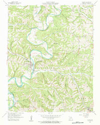
1956 Map of Galena
USGS Topo · Published 1957About this map
The James River carves a winding path through the Ozark hills of Stone County, where the town of Galena serves as a focal point for this 1950s landscape. This survey captures a moment when the Missouri Pacific railroad was still a primary corridor through the steep hollows, such as Powder Mill Hollow and Sugar Tree Hollow. The settlement pattern is deeply tied to the terrain, with family legacy marked at Parsons Cem and Bass Cem, while community life centers around the Oto Ch and Christian Union Ch. At the southeast edge, Reeds Spring sits near the head of several hollows, illustrating the classic ridge-and-valley habitation of the region. The map also includes technical details of the era's hydrology, noting a Gaging Station on Crane Creek and the presence of Cave Spring, reflecting the area's complex karst topography.
Find a feature on this map
44 named features on this map. Tap any name to fly to it.
Don’t see what you’re looking for? This feature index may not catch every label — zoom into the map to look around manually.
Map Details
Editions of this 1956 Galena Map
2 editions found
Other maps of this area

1907 · Forsyth
USGS Topo · 1:125,000

1927 · Shell Knob
USGS Topo · 1:62,500

1942 · Aurora
USGS Topo · 1:62,500

1945 · Harrison
USGS Topo · 1:250,000

1945 · Aurora
USGS Topo · 1:62,500

1949 · Harrison
USGS Topo · 1:250,000

1950 · Shell Knob
USGS Topo · 1:62,500

1950 · Garber
USGS Topo · 1:24,000

1954 · Harrison
USGS Topo · 1:250,000
1955 · Hurley
USGS Topo · 1:24,000