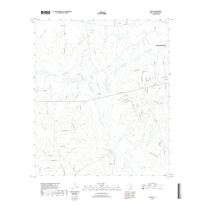
2019 Map of Galilee
USGS Topo · Published 2019About this map
Huntsville forms the northeastern anchor of this landscape, where the outskirts of the city meet the wooded drainages of Walker County. The terrain is defined by the winding course of the W Fork San Jacinto River and its numerous tributaries, including McGary Cr and White Oak Cr. This 2019 survey documents a rural environment transitioning toward residential development, yet it retains significant markers of its local history. Several family-named landmarks and ranch roads, such as Ward Ranch Rd and Hall Ranch Rd, persist alongside traditional rural spaces like the Ebenezer Cem. In the southern reaches, the Martha Chapel Cem serves as a key point of interest for genealogists tracing the legacy of early settlements near the W Fork San Jacinto River basin.
Find a feature on this map
73 named features on this map. Tap any name to fly to it.
Don’t see what you’re looking for? This feature index may not catch every label — zoom into the map to look around manually.
Map Details
Editions of this 2019 Galilee Map
This is the sole edition of this map. No revisions or reprints were ever made.
Other maps of this area

1954 · Beaumont
USGS Topo · 1:250,000

1957 · Beaumont
USGS Topo · 1:250,000

1959 · Moore Grove
USGS Topo · 1:24,000

1959 · San Jacinto
USGS Topo · 1:24,000

1962 · Pine Prairie
USGS Topo · 1:24,000

1962 · Richards
USGS Topo · 1:24,000

1962 · Galilee
USGS Topo · 1:24,000

1963 · Steep Branch
USGS Topo · 1:24,000

1963 · Crabbs Prairie
USGS Topo · 1:24,000
1963 · Loma
USGS Topo · 1:24,000