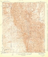
1943 Map of Galiuro Mts
USGS Topo · Published 1943About this map
The Galiuro Mountains dominate this high-desert landscape in southeastern Arizona, carved by a network of drainage systems including Copper Creek and Paddys River. This 1943 survey illustrates a region defined by remote ranching outposts and high-altitude mining operations. Cattle ranching is central to the area's geography, with the Simms Ranch, YLE Ranch, and Rhodes Ranch established near perennial water sources like Holdout Spr and Sunset Spring. These sites are often tucked into canyons like Mailbox Canyon or positioned near prominent peaks such as Bassett Peak and China Peak.
Find a feature on this map
74 named features on this map. Tap any name to fly to it.
Don’t see what you’re looking for? This feature index may not catch every label — zoom into the map to look around manually.
Map Details
Editions of this 1943 Galiuro Mts Map
2 editions found
Other maps of this area

1904 · Tucson
USGS Topo · 1:125,000

1905 · Tucson
USGS Topo · 1:125,000

1911 · Winkelman
USGS Topo · 1:125,000

1913 · Winkelman
USGS Topo · 1:125,000

1938 · Galiuro Mts
USGS Topo · 1:48,000

1938 · Klondyke
USGS Topo · 1:48,000

1940 · Sierra Bonita Ranch
USGS Topo · 1:62,500

1942 · Sierra Bonita Ranch
USGS Topo · 1:62,500

1943 · Galiuro Mts
USGS Topo · 1:62,500

1943 · Klondyke
USGS Topo · 1:62,500