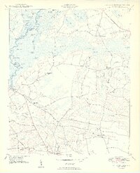
1950 Map of Galivants Ferry
USGS Topo · Published 1950About this map
Galivants Ferry sits on the eastern bank of the Little Pee Dee River, serving as a focal point for this agrarian landscape in Horry Co and Marion Co. The river system defines the western edge of the quadrangle, characterized by a complex network of backwaters and islands including Pee Dee I, Snowbird Lake, and Bear Knot Island. Away from the river, the terrain transitions into the expansive Lake Swamp, where timber and drainage patterns shaped local development.
Find a feature on this map
75 named features on this map. Tap any name to fly to it.
Don’t see what you’re looking for? This feature index may not catch every label — zoom into the map to look around manually.
Map Details
Editions of this 1950 Galivants Ferry Map
3 editions found

Other maps of this area

1943 · Adrian
USGS Topo · 1:24,000

1943 · Horry
USGS Topo · 1:24,000

1944 · Adrian
USGS Topo · 1:31,680

1946 · Johnsonville
USGS Topo · 1:62,500

1946 · Mullins
USGS Topo · 1:24,000

1947 · Centenary
USGS Topo · 1:24,000

1947 · Mullins
USGS Topo · 1:24,000

1948 · Galivants Ferry
USGS Topo · 1:24,000

1948 · Nichols
USGS Topo · 1:24,000

1948 · Bayboro
USGS Topo · 1:24,000