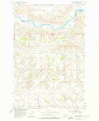
1954 Map of Gallatin Rapids
USGS Topo · Published 1976About this map
The Missouri River carves a sharp path through this portion of the Montana badlands, defining the border between Blaine County and Fergus County. In this mid-century landscape, the waterway is characterized by significant navigation hazards like the Gallatin Rapids and Dauphin Rapids. To the south, the terrain rises sharply into the prominent Whiskey Ridge, a high plateau dissected by numerous drainages such as Dog Creek. The map records early industrial activity in this remote area, specifically at Oil Well Hill where a singular Oil Well is noted. Landmarks like Sugarloaf Rock, Leslie Point, and Jones Cone provide navigational reference points across the broken topography, while several triangulation stations, including VABM 3303 Gallatin, mark the highest elevations and the progress of the Missouri River Basin development program.
Find a feature on this map
14 named features on this map. Tap any name to fly to it.
Don’t see what you’re looking for? This feature index may not catch every label — zoom into the map to look around manually.
Map Details
Editions of this 1954 Gallatin Rapids Map
2 editions found
Other maps of this area

1954 · Taffy Ridge
USGS Topo · 1:24,000

1954 · Leroy
USGS Topo · 1:24,000

1954 · Gallatin Rapids
USGS Topo · 1:24,000

1954 · Council Island
USGS Topo · 1:24,000

1954 · Lewistown
USGS Topo · 1:250,000

1959 · Lewistown
USGS Topo · 1:250,000

1964 · Anderson Bridge
USGS Topo · 1:24,000

1964 · Ragland Bench
USGS Topo · 1:24,000

1964 · Chase Hill
USGS Topo · 1:24,000
1985 · Winifred East
USGS Topo · 1:24,000