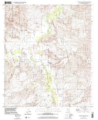
1996 Map of Galleta Flat East
USGS Topo · Published 2002About this map
The San Pedro Valley cuts through this landscape, centered on the San Pedro River as it flows between the Rincon Mts and the surrounding high desert of Cochise County. This 1996 update, based on aerial imagery, reveals a landscape defined by seasonal water management and ranching infrastructure, notably at the Singing Wind Ranch. The map captures a transition from the structured plots of Galleta Flat to the winding paths of Cornfield Canyon.
Find a feature on this map
18 named features on this map. Tap any name to fly to it.
Don’t see what you’re looking for? This feature index may not catch every label — zoom into the map to look around manually.
Map Details
Editions of this 1996 Galleta Flat East Map
This is the sole edition of this map. No revisions or reprints were ever made.
Other maps of this area

1915 · Benson
USGS Topo · 1:125,000

1922 · St. David
USGS Topo · 1:62,500

1926 · Whetstone
USGS Topo · 1:62,500

1943 · Benson
USGS Topo · 1:125,000

1943 · Dragoon
USGS Topo · 1:62,500

1945 · Happy Valley
USGS Topo · 1:62,500

1956 · Nogales
USGS Topo · 1:250,000

1956 · Tucson
USGS Topo · 1:250,000

1958 · Nogales
USGS Topo · 1:250,000

1958 · Tucson
USGS Topo · 1:250,000