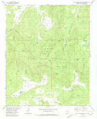
1981 Map of Gallo Mountains East
USGS Topo · Published 1981About this map
Gallo Mountains define this high-altitude landscape in western New Mexico, where the Apache National Forest dominates the terrain. This 1981 edition shows a region managed for seasonal resource use and ranching, evidenced by the high density of named water sources like Davis Windmill and the Old State Tank. The map reveals a complex network of springs, such as Armijo Spring and Malpais Spring, which were vital for sustaining livestock and wildlife across the dry canyons. Geographically, the area is dissected by numerous drainages including Gallita Canyon and Harris Canyon. These deep cuts, along with Agua Fria Mountain, highlight a landscape where human passage was largely limited to a network of jeep trails and pack trails, tracing a pattern of land use that prioritized access to reliable water in a challenging environment.
Find a feature on this map
51 named features on this map. Tap any name to fly to it.
Don’t see what you’re looking for? This feature index may not catch every label — zoom into the map to look around manually.
Map Details
Editions of this 1981 Gallo Mountains East Map
This is the sole edition of this map. No revisions or reprints were ever made.
Other maps of this area

1915 · Reserve
USGS Topo · 1:125,000

1918 · Pelona
USGS Topo · 1:125,000

1918 · Reserve
USGS Topo · 1:125,000

1954 · Clifton
USGS Topo · 1:250,000

1954 · Saint Johns
USGS Topo · 1:250,000

1957 · Clifton
USGS Topo · 1:250,000

1957 · Saint Johns
USGS Topo · 1:250,000

1958 · Clifton
USGS Topo · 1:250,000

1958 · Saint Johns
USGS Topo · 1:250,000

1962 · Clifton
USGS Topo · 1:250,000