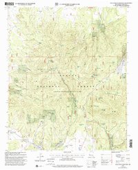
1999 Map of Gallo Mountains West
USGS Topo · Published 2002About this map
The Continental Divide winds through this high-elevation landscape in Catron County, New Mexico, marking the structural spine of the Gallo Mountains. This region, within the Apache National Forest, is defined by a dense network of drainages and springs that support livestock and local ecology. Named features like Fox Mtn and Gallo Peak rise above the complex system of canyons, including Lawson Canyon and Hardcastle Canyon. Water management is central to the land's utility, evidenced by the numerous tanks and windmills such as Candy Windmill and Uno Pino Windmill scattered across the high flats. The presence of Jewett Mesa and the Jewett Gap suggest a reliance on these natural corridors for movement through the high country, while the Roadside Park near the mountains' edge indicates accessible recreation within the forest boundaries.
Find a feature on this map
62 named features on this map. Tap any name to fly to it.
Don’t see what you’re looking for? This feature index may not catch every label — zoom into the map to look around manually.
Map Details
Editions of this 1999 Gallo Mountains West Map
This is the sole edition of this map. No revisions or reprints were ever made.
Other maps of this area

1915 · Reserve
USGS Topo · 1:125,000

1918 · Reserve
USGS Topo · 1:125,000

1954 · Clifton
USGS Topo · 1:250,000

1954 · Saint Johns
USGS Topo · 1:250,000

1955 · Red Hill
USGS Topo · 1:24,000

1957 · Clifton
USGS Topo · 1:250,000

1957 · Saint Johns
USGS Topo · 1:250,000

1958 · Clifton
USGS Topo · 1:250,000

1958 · Saint Johns
USGS Topo · 1:250,000

1962 · Clifton
USGS Topo · 1:250,000