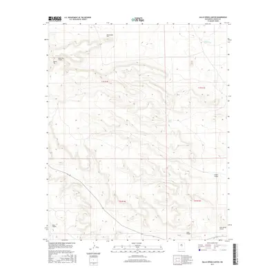
2017 Map of Gallo Spring Canyon
USGS Topo · Published 2017About this map
Gallo Spring serves as a vital focal point in this arid reach of Lincoln County, where the landscape is defined by a complex network of seasonal drainage and high points. The terrain is deeply incised by watercourses such as Cola del Gallo Arroyo and a series of significant canyons, including Gallo Spring Canyon, Taylor Canyon, and Miner Canyon. These geological features suggest a history of seasonal water management and grazing in a region where reliable springs were essential for survival.
Find a feature on this map
16 named features on this map. Tap any name to fly to it.
Don’t see what you’re looking for? This feature index may not catch every label — zoom into the map to look around manually.
Map Details
Editions of this 2017 Gallo Spring Canyon Map
This is the sole edition of this map. No revisions or reprints were ever made.
Other maps of this area

1954 · Fort Sumner
USGS Topo · 1:250,000

1958 · Fort Sumner
USGS Topo · 1:250,000

1980 · Corona
USGS Topo · 1:100,000

1981 · Gallo Spring Canyon
USGS Topo · 1:24,000

1981 · Camaleon Draw West
USGS Topo · 1:24,000

1981 · Camaleon Draw East
USGS Topo · 1:24,000
1981 · Pelon Hill
USGS Topo · 1:24,000
1981 · Red Bluff Draw East
USGS Topo · 1:24,000

1981 · Corona South
USGS Topo · 1:24,000
1981 · Gallo Spring Canyon NE
USGS Topo · 1:24,000