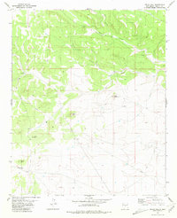
1981 Map of Pelon Hill
USGS Topo · Published 1981About this map
Lovelace Ranch sits at the base of a series of ridges and deep drainage systems in Lincoln County during the early 1980s. The landscape is defined by its vertical relief, with prominent peaks like Pelon Hill and Little Pelon Hill overlooking a network of dry watercourses including Dark Canyon, Bonita Canyon, and South Well Canyon. This area represents a typical high-desert ranching and resource environment, where human presence is sparse and concentrated near established structures and vital water sources.
Find a feature on this map
13 named features on this map. Tap any name to fly to it.
Don’t see what you’re looking for? This feature index may not catch every label — zoom into the map to look around manually.
Map Details
Editions of this 1981 Pelon Hill Map
This is the sole edition of this map. No revisions or reprints were ever made.
Other maps of this area

1954 · Fort Sumner
USGS Topo · 1:250,000

1955 · Roswell
USGS Topo · 1:250,000

1958 · Fort Sumner
USGS Topo · 1:250,000

1958 · Roswell
USGS Topo · 1:250,000

1962 · Roswell
USGS Topo · 1:250,000

1973 · Ancho
USGS Topo · 1:24,000

1973 · Chupadero Mountain
USGS Topo · 1:24,000

1980 · Corona
USGS Topo · 1:100,000

1981 · Gallo Spring Canyon
USGS Topo · 1:24,000

1981 · Rough Mountain
USGS Topo · 1:24,000