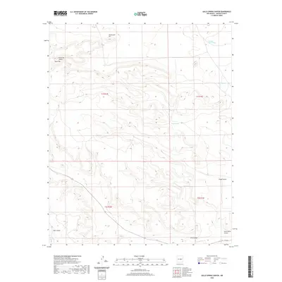
2020 Map of Gallo Spring Canyon
USGS Topo · Published 2020About this map
Gallo Spring serves as a central point of interest in this high-desert landscape of Lincoln County, where the terrain is defined by a series of significant drainage systems and elevations. The northern reaches are anchored by Rattlesnake Hill and the distinctive peak of Round Top, while the hydrology is dominated by the Cola del Gallo Arroyo. The map reveals a complex network of canyons that have shaped the region's movement and land use, including Taylor Canyon, Miner Canyon, and Hodge Canyon. These geological features suggest a landscape where water access was a primary driver for any local activity. The survey illustrates the intersection of Township 1 South and Township 2 South, providing a detailed look at the cadastral boundaries that organize this part of New Mexico. The presence of named features like Mesa Canyon and Gallo Spring Canyon points to a geography deeply tied to its seasonal watercourses and prominent landforms.
Find a feature on this map
15 named features on this map. Tap any name to fly to it.
Don’t see what you’re looking for? This feature index may not catch every label — zoom into the map to look around manually.
Map Details
Editions of this 2020 Gallo Spring Canyon Map
This is the sole edition of this map. No revisions or reprints were ever made.
Other maps of this area

1954 · Fort Sumner
USGS Topo · 1:250,000

1958 · Fort Sumner
USGS Topo · 1:250,000

1980 · Corona
USGS Topo · 1:100,000

1981 · Gallo Spring Canyon
USGS Topo · 1:24,000

1981 · Camaleon Draw West
USGS Topo · 1:24,000

1981 · Camaleon Draw East
USGS Topo · 1:24,000
1981 · Pelon Hill
USGS Topo · 1:24,000
1981 · Red Bluff Draw East
USGS Topo · 1:24,000

1981 · Corona South
USGS Topo · 1:24,000
1981 · Gallo Spring Canyon NE
USGS Topo · 1:24,000