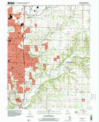
1996 Map of Galloway
USGS Topo · Published 2000About this map
The eastern expansion of Springfield is well underway in this mid-1990s record, as suburban development pushes toward the James River. This area serves as a transition between the urban core and the rural landscape of eastern Greene County, where older settlements like Galloway and Turners (Turner Station) maintain their distinct identities alongside emerging residential blocks. The land is marked by numerous family-named landmarks and country churches, such as Kinser Chapel and Oakland Ch, indicating the long-standing community roots in the region.
Find a feature on this map
62 named features on this map. Tap any name to fly to it.
Don’t see what you’re looking for? This feature index may not catch every label — zoom into the map to look around manually.
Map Details
Editions of this 1996 Galloway Map
This is the sole edition of this map. No revisions or reprints were ever made.
Other maps of this area

1884 · Springfield
USGS Topo · 1:125,000

1886 · Springfield
USGS Topo · 1:125,000

1935 · Springfield
USGS Topo · 1:24,000

1937 · Galloway
USGS Topo · 1:24,000

1937 · Ozark
USGS Topo · 1:48,000

1943 · Ozark
USGS Topo · 1:62,500

1945 · Ozark
USGS Topo · 1:62,500

1946 · Bassville
USGS Topo · 1:24,000

1947 · Strafford
USGS Topo · 1:62,500

1948 · Bassville
USGS Topo · 1:24,000