
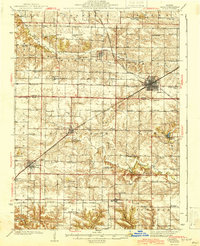
1944 Map of Galva
USGS Topo · Published 1944About this map
Bishop Hill stands as a prominent landmark in this mid-century portrait of Henry and Knox Counties, preserving the footprint of the historic communal settlement alongside its neighboring agricultural townships. The landscape is defined by a dense network of local education and faith, featuring numerous country schoolhouses like the uniquely named Octagon Sch and Swank College Sch, alongside rural centers such as North Ontario Ch. The region's development is anchored by the Chicago Burlington And Quincy railroad, which links the primary hubs of Galva and Oneida.
Find a feature on this map
83 named features on this map. Tap any name to fly to it.
Don’t see what you’re looking for? This feature index may not catch every label — zoom into the map to look around manually.
Map Details
Editions of this 1944 Galva Map
2 editions found
Other maps of this area

1925 · Galesburg
USGS Topo · 1:62,500

1927 · Galesburg
USGS Topo · 1:62,500

1929 · Annawan
USGS Topo · 1:62,500

1931 · Galva
USGS Topo · 1:48,000

1932 · Annawan
USGS Topo · 1:62,500

1934 · Geneseo
USGS Topo · 1:62,500

1937 · Orion
USGS Topo · 1:62,500

1940 · Galva
USGS Topo · 1:62,500

1941 · Maquon
USGS Topo · 1:62,500

1943 · Maquon
USGS Topo · 1:62,500