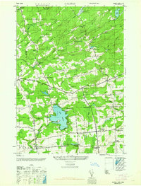
1945 Map of Galway
USGS Topo · Published 1962About this map
Lake Galway and the southern reaches of Adirondack State Park dominate this landscape, reflecting a 1940s rural economy rooted in small milling hamlets and local crossroads. The mapping reveals a high density of named corners and mills, including Hagedorns Mills and Parkis Mills, which grew along the complex hydrology of Glowegee Creek and Chuctanunda Cr. Notable for local history is the County Sanatorium located near Wiley Corners, a specialized facility situated on the higher elevations above Cadman Creek. The settlement pattern is characterized by numerous family-named landmarks such as Bunn Corners, Holsapple Corners, and Skinner Corners, marking the intersections that served as the social centers for this Saratoga County community during the mid-twentieth century.
Find a feature on this map
68 named features on this map. Tap any name to fly to it.
Don’t see what you’re looking for? This feature index may not catch every label — zoom into the map to look around manually.
Map Details
Editions of this 1945 Galway Map
This is the sole edition of this map. No revisions or reprints were ever made.
Other maps of this area

1893 · Schenectady
USGS Topo · 1:62,500

1895 · Schenectady
USGS Topo · 1:62,500

1895 · Amsterdam
USGS Topo · 1:62,500

1898 · Schenectady
USGS Topo · 1:62,500

1899 · Broadalbin
USGS Topo · 1:62,500

1902 · Broadalbin
USGS Topo · 1:62,500

1902 · Saratoga
USGS Topo · 1:62,500

1930 · Schenectady
USGS Topo · 1:62,500

1931 · Amsterdam
USGS Topo · 1:62,500

1935 · Middle Grove
USGS Topo · 1:24,000