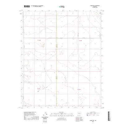
2023 Map of Gammil Well
USGS Topo · Published 2023About this map
The Mesa dominates the northeastern corner of this remote landscape along the border of De Baca County and Roosevelt County. This 2023 survey by the U.S. Geological Survey depicts a high-desert environment defined by the Public Land Survey System grids of Township 1 South and Township 2 South. The topography is marked by subtle elevation changes and drainages, with the long stretch of Gunsmoke Rd serving as one of the few primary transportation corridors through the western portion of the quadrangle. The map reveals the sparse network of rural routes that crisscross the arid terrain, providing a contemporary view of land divisions and property boundaries in this section of eastern New Mexico.
Find a feature on this map
2 named features on this map. Tap any name to fly to it.
Don’t see what you’re looking for? This feature index may not catch every label — zoom into the map to look around manually.
Map Details
Editions of this 2023 Gammil Well Map
This is the sole edition of this map. No revisions or reprints were ever made.
Other maps of this area

1954 · Fort Sumner
USGS Topo · 1:250,000

1954 · Clovis
USGS Topo · 1:250,000

1958 · Fort Sumner
USGS Topo · 1:250,000

1958 · Clovis
USGS Topo · 1:250,000
1967 · Howell Ranch
USGS Topo · 1:24,000
1967 · Watts Hill
USGS Topo · 1:24,000

1968 · Lomas Gatos
USGS Topo · 1:24,000

1973 · Gammil Well SE
USGS Topo · 1:24,000
1973 · Gammil Well
USGS Topo · 1:24,000

1973 · Gammil Well NE
USGS Topo · 1:24,000