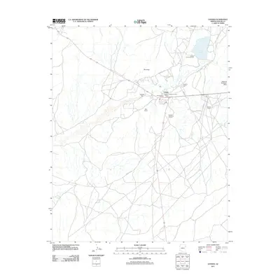
2011 Map of Ganado
USGS Topo · Published 2011About this map
Ganado serves as the central hub of this 2011 survey, situated within the high desert landscape of Apache County. The town is marked by significant cultural and community institutions, including the Ganado Trading Post, the Round Top Trading Post, and the Ganado Mission Cemetery. The presence of these historic trading posts reflects the long-standing importance of this area as a site of commerce and social gathering. To the north, the waters of Ganado Lake and the adjacent Ganado Lake Campground offer a sharp contrast to the surrounding arid terrain, which is defined by features such as Hubbell Hill, Round Top, and Red Point. A network of thoroughfares, including Indian Rte 27 and Indian Rte 151, connects the scattered settlements and natural landmarks, while the Ganado Airport provides an essential link to the broader region.
Find a feature on this map
21 named features on this map. Tap any name to fly to it.
Don’t see what you’re looking for? This feature index may not catch every label — zoom into the map to look around manually.
Map Details
Editions of this 2011 Ganado Map
This is the sole edition of this map. No revisions or reprints were ever made.
Other maps of this area

1886 · Fort Defiance
USGS Topo · 1:250,000

1892 · Fort Defiance
USGS Topo · 1:250,000

1954 · Gallup
USGS Topo · 1:250,000

1955 · Zith-Tusayan Butte 3 NW
USGS Topo · 1:24,000

1955 · Zith-Tusayan Butte 2 SW
USGS Topo · 1:24,000
1955 · Nazlini
USGS Topo · 1:62,500

1958 · Gallup
USGS Topo · 1:250,000

1959 · Gallup
USGS Topo · 1:250,000

1962 · Gallup
USGS Topo · 1:250,000

1967 · Gallup
USGS Topo · 1:250,000
Featured Places
- Fort Defiance Agency
- Ganado, Fort Defiance Agency
- Nátʼohchǫʼí, Fort Defiance Agency
- Apache County, AZ
- United States