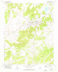
1973 Map of Ganado
USGS Topo · Published 1976About this map
Hubbell Trading Post National Historic Site stands as a central landmark on the Navajo Indian Reservation, anchoring this 1970s survey of the high plateau country. The settlement of Ganado is depicted at a moment of significant institutional growth, featuring the Ganado Mission, the College of Ganado, and the local High Sch. This intersection of traditional commerce and modern education is situated along the banks of the Pueblo Colorado Wash, which meanders through a landscape defined by Ganado Mesa and nearby Sand Dunes.
Find a feature on this map
34 named features on this map. Tap any name to fly to it.
Don’t see what you’re looking for? This feature index may not catch every label — zoom into the map to look around manually.
Map Details
Editions of this 1973 Ganado Map
This is the sole edition of this map. No revisions or reprints were ever made.
Other maps of this area
1886 · Fort Defiance
USGS Topo · 1:250,000
1892 · Fort Defiance
USGS Topo · 1:250,000
1954 · Gallup
USGS Topo · 1:250,000
1955 · Zith-Tusayan Butte 3 NW
USGS Topo · 1:24,000
1955 · Zith-Tusayan Butte 2 SW
USGS Topo · 1:24,000
1955 · Nazlini
USGS Topo · 1:62,500
1958 · Gallup
USGS Topo · 1:250,000
1959 · Gallup
USGS Topo · 1:250,000
1962 · Gallup
USGS Topo · 1:250,000
1967 · Gallup
USGS Topo · 1:250,000
Featured Places
- Fort Defiance Agency
- Ganado, Fort Defiance Agency
- Nátʼohchǫʼí, Fort Defiance Agency
- Apache County, AZ
- United States